Frankenstorm: Hurricane Sandy is Born
by Marilyn Muir, LPMAFA

This work is licensed under a Creative Commons Attribution-NonCommercial-ShareAlike 4.0 International License.
On October 19, 2012, between Honduras and the Cayman Islands in the Caribbean, an area of air / sea disturbance developed. The earliest official report I could locate was 4:40 PM EDT, October 19th, from a reconnaissance flight by the National Hurricane Service in Miami, FL. Astrologers should cast a ballpark noonmark chart because actual time was both unknown and unknowable.
- Cayman Islands 19 N20, 81 W 24 EDT
- Honduras 14 N 36, 87 W 13
The midpoint coordinates I used for the developing storm itself were 17 N 00 and 84 W19. EST was the default in my IO astrology program (Time Cycles).
The disturbance rapidly escalated to a tropical wave, a tropical depression, and finally a named tropical storm on October 22 at officially 11:00 AM EST in the Caribbean waters. The list of names for developing storms is always announced before hurricane season begins. Names are assigned in alphabetical order as they develop. The assignment of a name gave Tropical Storm Sandy its specific identity. The location coordinates were not changed.
Sandy continued to escalate forming the characteristic “eye” with winds to hurricane category 1 status. Hurricane Sandy would eventually make the record books. The eye of a hurricane is quite small compared to the whole of the storm, perhaps twenty to thirty miles wide; but high winds circle this core, building speed and intensity – the eye. These winds fan out from the center like a whirlpool into storm bands, developing literally “arms” rapidly feeding the whole system. The damaging winds and rain enveloped and wracked the Caribbean Island nations as Sandy made her first landfall as a category 1 hurricane near Kingston, Jamaica on October 24th at 3:00 PM EDT (news source; IO gave EST).
Teaching Moment: Life is a process, not a series of unrelated incidents. When the nuclear reactor at Chernobyl exploded, I was able to get the actual timeline of events from a book called Swords Into Plowshares. It taught me the value of timing an activity, step by step, to watch an actual process develop. For this series on a developing storm, I plan to show five astrological stages of Sandy: the time she began (which is speculative), the time she was named (which is speculative as well, but closer to accurate than our birth possibility), plus the three timed landfalls. Knowing the exact moment the air was disturbed in the Caribbean Sea was just not feasible, but it is logical to assume it did occur sometime prior to the announcement on the 19th. Hours? Days? This is too nebulous to ever know for sure, but we can see what aspects were forming that could be acted upon for the next two weeks, the process of the development of Sandy. What applying aspects could be triggered repeatedly? And surprisingly, we recognized even earlier time markers.
Birth: Several configurations were in place or forming that could be key to this story. Remember such aspects are in place for all forms of birth over the entire globe and not every one of those births produce this type of stress. We are searching for keys, and this is where to begin. Notice I said keys. Such a massive event cannot be produced by a single aspect. It must be produced by a multiple of aspects. In my practice, applying aspects represent future culmination and separating aspects represent history. I use hard action aspects, tight orbs. What is or is coming into play that can last over the range of time required for this hurricane, in this instance about two weeks? Start with the Hurricane Sandy discovery (reconnaissance) chart.
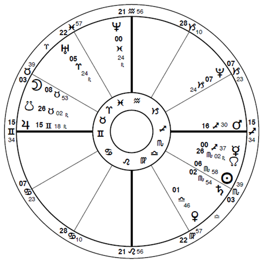
Hurricane Sandy Begins
October 19, 2012; 12:00 PM EST
Middle of the Caribbean
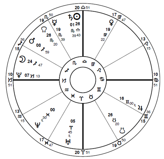
- Transiting Uranus/Pluto square, which is bedeviling the entire world in some way, close to an angle: Pluto conjunct the Ascendant.
- T-square: Mars widely opposite Jupiter, which does occur about every two plus years due to Mars’ orbital speed. In this chart, both planets are applying and would have also been in play a few days prior with Venus square first one then the other.*
- The Moon has moved 16˚ past the conjunction to Mars, so the actual conjunction existed about 32 hours earlier in this process (actual birth?). The Moon travels approximately 1˚ every two clock hours.
- Sun / Saturn conjunction wide, out of sign but applying, processing toward the future.
- Mercury widely conjunct N Node, applying, processing towards future.
Can you see where I am going with this possibility? If applying shows future activity, separating can show us historical activity. Timing is done by actual planetary motion as in rectification.
Named: The official announcement gave the name assigned by weather central. Assignment of name is done when a storm has fully organized, and the winds are both strong and are gathering strength. What will become Hurricane Sandy at that point is a windy rainstorm, with a strong counter-clockwise, circular pattern developing. Which of the speculative aspects are still in play? Some have just completed the perfected aspect, indicating the passage of time between identification of a stage and announcement, timing. What has not perfected is the present moving towards the future.
Hurricane Sandy Named
October 22, 2012; 11:00 AM EST Middle of the Caribbean
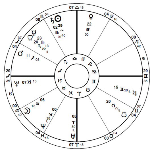
- Mars / Jupiter are getting tighter, Venus is now separating (the past) from the previously existing T-square* which she activated and connected, first one and then the other.
- The Moon has moved about 6 to 8˚ past the square to the Sun / Saturn conjunction, or about twelve to sixteen hours on the clock.
- The Uranus / Pluto square is more tightly aspected to the IC angle (2˚).
- Mercury is tightening the conjunction to the N Node.
Sandy is growing into a hurricane, stage by stage.
First landfall: Kingston, Jamaica Timed, so the chart is far more trustworthy, but note that in my personal experience the initial impact of any hurricane is when the leading edge of the hurricane passes over the area of landfall prior to technical landfall, which is the eye. When the eye wall itself passes over a single point, calm descends for a short time and it appears the storm is over (been there, done that). It is not over because the other half must now pass over that location, but it will not usually be quite as strong. I am sure there are exceptions to any basic rule including this one. I have witnessed one such hurricane pattern in south Florida where the second half of the storm was factually stronger than the leading edge. Went right over my son’s home. Hurricanes are very individualized in nature.
Teaching Moment: When I constructed this chart, IO listed it as EST. I double checked that. Not all the Caribbean islands conform to daylight savings times. I did not want to leave confusion by a possible difference in time standard. I trusted the embedded computer timing.
Hurricane Sandy Kingston
October 24, 2012; 3:00 PM EST
Kingston, Jamaica
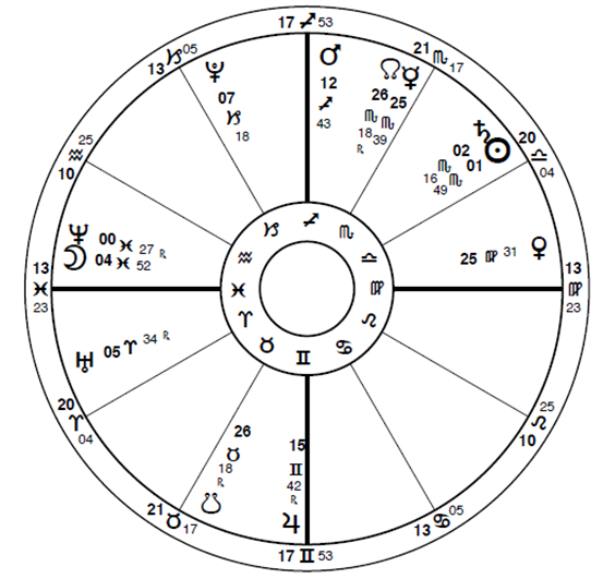
- Mars / Jupiter in tightening opposition straddle the MC / IC axis square the Ascendant / Descendant axis.
- Uranus / Pluto are angular in the 1st and 10th.
- Venus separating from the T-square is now quiescent in 7th. That will change, stay tuned.
- The Sun / Saturn conjunction is close to exact, applying.
- The Mercury and N Node are close to exact, applying.
- The Moon is separating from the conjunction to Neptune by 4˚.
4˚x 2 hr = exact 8 hours earlier; unknown application or it might have been when the leading edge of the hurricane crossed the landfall threshold.
Second landfall: Santiago, Cuba Going over land, particularly mountains, weakens any tropical system. But Jamaica is small and the warm waters to its north revived the storm. Sandy then made its second landfall as a category 2 hurricane just west of Santiago, Cuba on Oct 25th at 1:25 AM EDT (IO timing).
Hurricane Sandy Santiago
October 25, 2012; 1:25 PM EDT
Santiago, Cuba
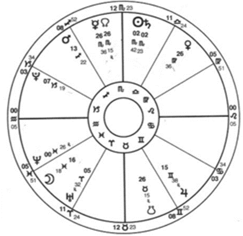
- The Sun / Saturn conjunction is now complete, square the landfall Ascendant / Descendant, applying; the Ascendant moves faster than the planets.* Although now separating, the applying angles provide the connection as a re-energizing function for that aspect.
- The Mars / Jupiter opposition continues to tighten, and you thought it was a minor pattern because it occurs every two years like clockwork. It accompanied other contributing aspects, one piece of a larger generating energy.
- The transiting Moon is now T-square the Mars/Jupiter opposition, slightly past; see transiting Moon preliminary damage explanation above.
- Venus is in the 8th of catastrophe, quiescent at the moment – but keep watching.
- The Mercury / N Node conjunction was exact a few hours prior (leading edge impact?). Mercury is traveling 57’ direct, the Node 3’ retrograde, which equals 54 minutes of direct motion to the pair each 24 hours on the clock. 54’ ÷ by 24 hours = 2+ minutes per hour, 21 minutes of separation between the two ÷ 2+ minutes = about 10 hours earlier on the clock.
Teaching Moment: Again, landfall over, land (but this time with high mountains) weakened Sandy. But the island nation is narrow south to north. Sandy headed out over the warm waters where the Gulf of Mexico meets the Atlantic Ocean and followed the Gulfstream of warm water, which flows up the eastern U.S. seaboard. Warm water acts as the engine to power any hurricane. The storm can still fluctuate in intensity and categorization if other factors enter in such as other weather fronts or steering currents. On October 28th, the eye began re-development as Sandy reorganized and re-energized. No other weather pattern curtailed or derailed the development of the hurricane.
Sandy followed a NNE track thru these early stages and appeared to me to ride the Gulfstream northward along the coast. At one point, Bermuda was warned that the storm was a threat but that did not transpire. Intensity and direction fluctuations befuddle scientists as they attempt to get a fix on the possibility of any hurricane’s impact. As we watched, the storm engorged and enlarged as it traveled up the east coast. The effect of Sandy was felt all the way up the east coast but the eye itself stayed well out to sea, the warm waters powering it, generating the intensity and fury… and it kept growing.
Teaching Moment: Tropical systems are generally but not always full of water. For example, Hurricane Andrew was a comparatively drier hurricane. It acted more like a thirty-mile wide (the eyewall) tornado across South Florida. I was in Fort Lauderdale at that moment in time and went to south Miami to give aid. I saw what that hurricane did in damage and how it had acted. Regardless of intensity or direct impact, water-filled hurricanes can cause excessive flooding and storm surges that can be devastating. I currently live in central Florida, and I have witnessed both such experiences.
Ordinarily, the NE quadrant is the power point for highest impact, with tornados and major storms embedded in the eyewall itself and in the feeder bands in that top / right quadrant. But Hurricane Sandy was different. It was the NW quadrant that bombarded the U.S. coastal areas with water and high winds. An excess of water is just that – excessive. Not only is the water falling from the sky like a monsoon, but the storm is pushing the
waters in towards the coastline causing rivers to build their levels to flood stage as the sea tide relentlessly attacks the coastline. This is particularly devastating at high tide or coincident with a New or Full Moon. Where would Sandy make landfall on the U.S. east coast? It appeared for a time to perhaps move away from the shore. But wait… there was another major contributing factor.
The end of October signifies advancing colder weather in the northern part of the U.S. Cooling air from the Canadian west and north Arctic regions begin their winter reign. A major winter storm was approaching the eastern seaboard states from the north and west. The realization that the two storms would meet and combine was truly frightening to me, from my forty years of hurricane watching. The cold storm would contribute a Nor’easter effect and the tropical storm would contribute a hurricane for a marriage the media called Frankenstorm. The Hollywood “storm of the century” movie happened in real life as we helplessly watched and waited. Reality imitated fiction. But unlike the Hollywood version, the crescendo of storm landfall would not be the end of the movie. The victims are still victims, months and what will become years later. Unlike the crescendo of the movies, in reality this disaster had an afterlife.
As the hurricane traveled north, the incoming cold front caused the hurricane to lose its tropical features, but unfortunately not its strength. The cold front started to draw Sandy towards the coastline. The hurricane direction became more NNW… towards land. Sandy would not harmlessly flow out to sea as had been hoped. Its new trajectory gave it a third and final landfall on the heavily populated U.S. coastline.
Official weather websites illustrate that a tropical system has a circular eye, easily visible in the satellite images. However, when the storm becomes a post-tropical system, that eye circle will become a comma in shape. In all my study of hurricanes, I had not learned that before this event. The actual picture of this is given on several websites and this change to the merged system happened close to 11:00 PM, just prior to authoritative landfall as the cold front fully embraced the approaching now category 1 hurricane. The circle became a comma and the marriage between the two storms was consummated. The newlywed couple gave birth to a mega storm. Along with millions of other viewers, I watched my television with horror as the storm engulfed southern New Jersey five miles south of Atlantic City at 8:00 PM EST. Frankenstorm Sandy had landed. According to the multiple weather reports I researched, that elongated eye / comma hit the U.S. coast five miles south of Atlantic City, NJ just before midnight on October 29th / 30th.
Note: The multiple of published official impact reports are confusing, ranging from October 29th at 8:00 PM to just before midnight Oct 29 / 30. The 3.5’ video suggested at the bottom of this article has a digital clock running – check it for yourself.* Look at the size of the storm on the video. At its most expanded point, the storm enlarged to 1100 miles east to west becoming the largest mega storm on record. It totally obscured any land feature. Officially landfall seems to be listed as close to midnight, but my own eyes saw it land at 8 PM on television. What to do? I did both charts. After all, this is research. So, this specific landfall chart will be set for both 8 PM on October 29th and midnight October 30th. With that being offered, know that the storm continued to batter the northeast far past the point of landfall and that might be what the two charts are referencing. At this point, both charts are potentially feasible.
As mentioned previously, the devastation began long before landfall as Sandy’s northwestern quadrant ran up the coastline. The storm had been stoked by water-filled feeder bands from the arms of the hurricane. Although winter storms are common up north, the Nor’easter was doing its own winter damage as it headed towards the merger. The mega storm feature developed as Sandy’s water-filled hurricane bands fed the Nor’easter. Savagery was the result. Coastline states experienced a deluge and the combined storm pounded 24 states in our country, a few for many hours. It also happened to be a Full Moon, and the higher tide engorged the land as an impact of the storm surge.
Tropical systems tend to weaken over land because they are powered by warm water, but this a merged storm. Cold fronts are born and powered over land and their power diminishes slowly as the combined front pushes through and slowly degenerates or flows out into the North Atlantic. Because it was a combined storm the time of devastation unfortunately elongated.
The mega storm was brutal and lethal, the aftermath and devastation unimaginable. The suffering of those affected is indescribable for our human comprehension. I wrote the first draft of some of these chapters just after the storm. The second re-write of those early chapters happened at the end of January, 2013, and multitudes of people in south New Jersey were still without power, utilities and the rudiments of existence. The devastation was beyond belief. The third and more complete re-write happened as a new winter storm, Nemo, impacted the U.S. east coast. More about Nemo in the ingress charts chapter.
Hurricane Sandy Landfall Atlantic City
October 29, 2012; 8:00 PM EDT
Atlantic City, NJ
Third and final landfall, Atlantic City. NJ 8 PM October 29, 2012
- Mars opposite Jupiter conjunct the Ascendant / Descendant axis, up close and personal, very tight, culmination. Mars / Jupiter is now just past exact, but being placed on the angles, the angles make it active and timely.* Or… perhaps the leading-edge impact described previously was the moment this aspect fulfilled its destiny.
- The Full Moon opposite the Sun / Saturn conjunction was now separating, on the 6th / 12th axis – health, victimization, or sabotage.* The Full Moon was four hours earlier, not necessarily timing the leading edge but could have signified the intense northern storm bands continually bombarding the coast. There can be, and usually are, more than one rotating band to a hurricane. Please remember the traveling diameter of Hurricane Sandy was 1100 miles east to west!
- Venus moved into early Libra and the nasty Uranus / Pluto existing square turned into an applying T-square with Pluto in the 8th of catastrophe* – and you thought Venus was quiescent and not part of this disaster. First, she triggered Mars, then Jupiter, now Uranus and Pluto. The outer planets will get the blame, but Venus connected the dots from one to the other. The word “she-devil” comes to mind for this application.
- The tight Mercury square Neptune can account for the combination of wind and water and the devastating lack of communications and transportation that occurred.
Hurricane Sandy Atlantic City Midnight
October 30, 2012; 12:00 AM EDT
Atlantic City, NJ
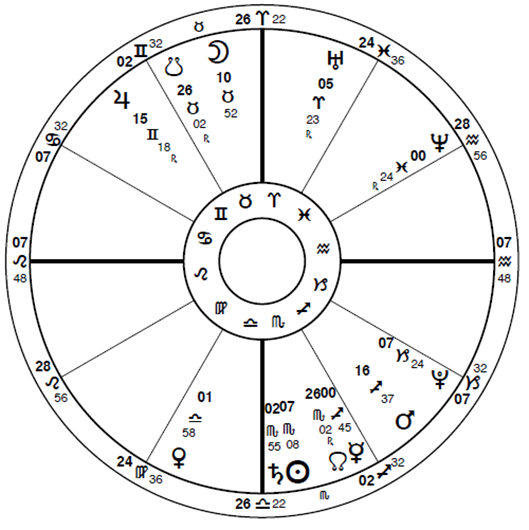
Alternative third and final landfall, Atlantic City, NJ midnight October 30, 2012
- The angular Full Moon is now several hours past peak (which was 3:50 PM local time). but the high tide had already done its damage. The nearby (think 1100 miles width of hurricane) New York City Subway was submerged and LaGuardia Airport was closed by flooding.
- Sun / Saturn is in the 4th opposite Moon / 10th still as a signature for the Full Moon. Even though the Sun / Saturn conjunction was separating, the Moon had triggered* the separating conjunction. It was alive and active: families, homes, property – all made public headlines.
- Not so quiescent Venus has moved into early Libra turning the Uranus / Pluto square into an applying T-square. The next 3 to 5˚ (or three to four days) would be critical as Venus opposed Uranus, both square Pluto. Remember the effects of this storm lasted way past landfall and will still be in effect many months to many years later.
- In the previous 24-48 hours Mars had completed its opposition to Jupiter. It had bought Sandy the whole way and had introduced her to her Nor’easter partner. The marriage was complete, and the disaster was the by-product or child of that marriage – Frankenstorm.
- Mercury square Neptune can account for the combination of wind and water and the devastating lack of communications and transportation that occurred at the point of actual U.S. landfall. Mercury was now at 00 Sagittarius.
As you can see, the two U.S. landfall charts have most aspects identical. I do see the 8:00 PM Mars opposite Jupiter almost exactly conjunct the Ascendant / Descendant axis as significant. But… it is not more significant than the midnight Sun / Saturn conjunction opposite the Full Moon square the Ascendant / Descendant axis. The duration of the storm allows for both charts to be pertinent to the event. This was a massive storm with not just hours, but literally days, of damage.
The effects were felt not only by the towns and cities of direct impact, but also by a full 24 states and the country itself. We are a complex, integrated society. What affects one area affects us all. While not diminishing the devastation to the Caribbean, the U.S. alone lost over 250 citizens who also were parents and children, neighbors and friends. None of us are isolated from one another. Our transportation, electric, environment, land erosion, communication, commerce, stock markets, political systems. etc. were collectively affected. And, yes, politics. This was election week and voting and early voting were very difficult for the impacted area, special arrangements had to be made. The New Jersey and New York political structures deserve applause for doing their very best to see that every citizen entitled to a vote got to vote. Could there have been errors in the voting process? Of course, that maybe exists – but they really did try.
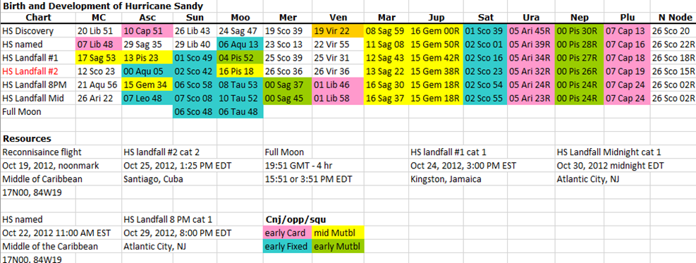
Please look at the chapter 1 spreadsheet to see all this information in a color-coded aspect format.
Where do we go from here? In the next two chapters we will look at the effects on two of the states most directly impacted: New Jersey and New York. Then we will look at the effect on the U.S. chart in combination with those two state charts, and additionally the effect on two points of landfall: Atlantic City, NJ and the megalopolis we call New York City. Additional chapters will focus on two major transportation giants: the New York City subway system and LaGuardia Airport, both of which were completely flooded and shut down.
Source Websites: We have the world’s largest library at hand, the internet, with too many sources to even imagine. Not all sources are accurate, so you must learn to check each source. What may not be a most accurate rendition may still have usable citations.
- For the science of it, use government or specific science sourcing.
- For the overall, use encyclopedic sources.
- For the stories and human interest or timing, use news sources.
- And, of course, you just cannot beat first person stories for the personal truth of it.
*If you have access to the internet, please look at the skyscript.uk.com glossary of astrological terms for Horary Astrology techniques called Collection of Light and Translation of Light at the two links given below. These antique astrological concepts have been used in this chapter and will be used several times to describe the development and utilization of aspects. A simple explanation of those techniques will be helpful as this material proceeds.
Original source material:
http://www.skyscript.co.uk/gl/collection.html
http://www.skyscript.co.uk/gl/translation_light.html
http:www.nhc/noaa.gov
Glossary of NHC terms – National Hurricane Center
2023: This has been removed from the site. I am appending my original reference here for description and source.
http://www.nasa.gov/mission_pages/hurr.icanes/archives/2012/h2012_Sandy.html
This is an amazing 3.5’ video from Oct 21 thru Oct 31, minute by minute.
“Satellite Captures the Life and Death of Hurricane Sandy on Halloween”
This animation of satellite imagery shows the life of Hurricane Sandy from its development in the Caribbean Sea on October 21, through its track up the U.S. East coast and landfall. The animation continues through October 31 when Sandy had weakened to a remnant low-pressure area. Credit: NASA GOES Project
http://en.wikipedia.org/wiki/Meteorological_history_of_Hurricane_Sandy
http://en.wikipedia.org/wiki/Effects_of_Hurricane_Sandy_in_New_Jersey
Wikipedia and other encyclopedic sources have many additional articles and cited references.
http://www.livescience.com/24380-hurricane-sandy-status-data.html
This work is licensed under a Creative Commons Attribution-NonCommercial-ShareAlike 4.0 International License.